- Lidar (light detection and ranging) uses eye-safe laser beams to “see” the world in 3D, providing machines and computers with an accurate representation of the surveyed environment.

Working
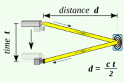
- A typical lidar sensor emits pulsed light waves into the surrounding environment.
- These pulses bounce off surrounding objects and return to the sensor.
- The sensor uses the time it took for each pulse to return to the sensor to calculate the distance it traveled.

- Repeating this process millions of times per second creates a precise, real-time 3D map of the environment. This 3D map is called a point cloud.
- A lidar determines the distance of an object or a surface with the formula.
d = c * t / 2.
where
- c is the speed of light.
- d is the distance between the detector and the object or surface being detected.
- and t is the time spent for the laser light to travel to the object or surface being detected, then travel back to the detector.
Applications of LiDAR Sensor
- Autonomous Vehicles- Lidar sensors are a key component in autonomous vehicles providing a high-resolution 3D view of their surroundings. Lidar enables autonomous vehicles to “see” by generating and measuring millions of data points in real-time, creating a precise map of its ever-changing surroundings for safe navigation. Lidar’s distance accuracy allows the vehicle’s system to identify and avoid objects at up to 300 meters in a wide variety of weather and lighting conditions.
- An onboard computer can utilize the lidar point cloud for safe navigation.
